 Click to enlarge
Garmin Navionics+ NSAE016R - Japan Lakes & Coastal - Marine Chart
Manufacturer: GarminPart #: 010-C1215-20SKU: 96005
Item #: 96005
Category: Garmin Navionics+ Foreign
Currently out of stock. This item isn't available to order right now — check back soon or contact us for availability.
- Ships from US warehouses
- Free shipping on orders over $99
- Secure checkout — your info is protected
- Genuine marine-brand parts, not knockoffs
- Marine parts support — we know boats
Description
Navionics+ NSAE016R - Japan Lakes & Coastal - Marine Chart Get the world’s No. 1 choice in the marine mapping with the best, most up-to-date Navionics®+ cartography on your compatible chartplotter.
Featuring vibrant colors, a streamlined interface and combined coastal/inland content with a popular Navionics® style color palette, Garmin Navionics+ cartography makes it easy to plot your course. Multiple shading options aid in shallow water navigation and make it easy to highlight a target depth range for the best fishing spots.
Fully customizable with various chart layers, overlay combinations and up to 10 color-shaded target depth ranges to scope out the best fishing spots. When you purchase a new Garmin Navionics+ or Garmin Navionics Vision+ cartography product, a one-year subscription is included.
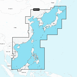
Chart Code - NSAE016R Coverage Area: Detailed coverage of coasts of Japan: from Yaeyama Islands, Okinawa to Aniva Bay and Kunashir Island. Coastal coverage of South Korea from Busan to Deoksan-ri.
Includes detailed coverage of most major lakes including Inawashiro, Kussharo, Ogawara, Onuma, Shikotsu, Shinji, Towada, and Toyako. Features: All-in-one Map Solution - Access detail-rich mapping of coastal features, lakes, rivers and more.
Integrated Garmin and Navionics® content offers coverage for boaters worldwide. Daily Chart Updates - Charts are constantly being enhanced with new and amended content — as many as 5,000 updates are made every day.
The one-year included subscription gives you access to daily chart updates via the ActiveCaptain app. Auto Guidance+ Technology - Combining the best of Garmin and Navionics automatic routing features, built-in Auto Guidance+ technology1 gives you a suggested dock-to-dock path to follow through channels, inlets, marina entrances and more.
Depth Range Shading - High-resolution depth range shading lets you select up to 10 color-shaded options and view your designated target depths at a glance. Up to 1' Contours - For improved fishing
Specifications
| Brand | Garmin |
|---|---|
| Part Number | 010-C1215-20 |
| EverTide SKU | 96005 |
| UPC | 753759289096 |
Specifications are provided by the manufacturer. Confirm fitment for your application before ordering, or contact us and we'll help.
Complete your setup
Returns & warranty
Charts and cartography are non-returnable once opened, in line with the manufacturer's policy. If your item arrives damaged or incorrect, contact us and we'll make it right.
Garmin productscarry the manufacturer's standard warranty. For a warranty claim or a return authorization, see our full returns policy or contact us.
Customer reviews
No reviews yet — this product.
Fast shipping
Ships from US warehouses — free over $99
The right part
Marine-grade parts matched to your boat
Real support
Questions? We know boats — call or email